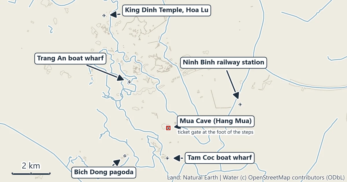
Hang Mua sits where the flat rice country south of Ninh Binh meets the karst. A short lane leaves the road at Khe Dau Ha village, passes a lotus pond and stops at the foot of a ragged limestone hill. Inside the hill is the cave that gave the place its name; up its side runs a stairway of white stone with carved balustrades, climbing to the summit of Ngoa Long, the Lying Dragon. The climb is short and steep, and the view from the top is the one people come for: the river of Tam Coc winding between towers of rock below, and the peaks of Trang An rising to the north-west.
What Mua Cave is
Three things share the name. Hang Mua, the cave, opens at the foot of a hill shaped, in the words of Ninh Binh’s tourism promotion centre, like a bell; the cave covers about 800 square metres. Nui Mua, the hill, is also called Ngoa Long, which means Lying Dragon. And the tourist area around them, Khu du lich Hang Mua, takes in the stairway, the lotus pond, a hotel and the ticket gate. When people say “Mua Cave” they nearly always mean the climb and the view.
The name means “dance cave”. The legend the province tells is that when a Tran king came to Hoa Lu and founded the Thai Vi hermitage, he would come to this cave to watch the women of the court sing and dance, and from then on the people of the area called it Hang Mua.
The hill lies inside the Trang An Landscape Complex, which UNESCO inscribed in 2014 as a mixed cultural and natural World Heritage property: 6,226 hectares of karst, rivers, caves and the old capital of Hoa Lu.
The climb
The stairway starts at the foot of the hill, a short walk from the ticket gate past the lotus pond, and climbs the ridge in switchbacks. How many steps it has depends on who counts: 486 on the Vietnamese page of Ninh Binh’s tourism promotion centre, nearly 500 on its English page, about 500 in press reports of the operator’s 2026 price notice. The walking route from the ticket gate to the summit is 0.67 km on foot. The steps are white stone, and the balustrades on either side are carved with dragons and phoenixes in the manner of Tran-period art. The steps page has the map and what to bring.
At the top
The summit carries a statue of Quan The Am, the bodhisattva of compassion, gazing down over the wide land of the old capital; a Buddhist pagoda; and a stone dragon laid along the summit ridge. Below to the south runs the boat river of Tam Coc; to the north-west rise the peaks of Trang An. See the summit and the dragon.
The lotus pond
At the foot of the hill a lotus pond fills the ground between the gate and the stairway, with a boardwalk across it, about 260 m long, measured on the map. The lotus is at its best in June and July, according to a 2023 piece in Vietnam’s tourism magazine (Tap chi Du lich); no managing body publishes a bloom calendar. See the lotus pond and the seasons.
Ticket and opening times
| Who | Ticket |
|---|---|
| Visitors over 1 m tall | 150,000 dong |
| Children under 1 m | free |
Prices from Ninh Binh’s 2026 ticket list (tourism promotion centre) and the Trang An management board’s ticket list, checked November 2026. The operator raised the ticket from 100,000 dong on 1 April 2026. No official body publishes opening hours; the hotline on the province’s list is 0987 111 312. More on the ticket page.
The 2026 floods and Tet: what closed
During the storm of late August 2026 and the floods of mid-September, Ninh Binh’s tourism department issued lists of sites that had paused or changed their routes. Hang Mua was not on any of them. The Trang An boat area was: it stopped all visits from 23 August, ran an adjusted route on 16 September and stopped again from 17 September 2026, until further notice; we found no reopening notice when we checked on 1 November 2026. At Tam Coc the boats ran a route without Hang Ba, the third cave, from 17 September, and the electric car to Bich Dong stopped. Over Tet 2026 the department listed Hang Mua as open on 16 and 17 February, the last day of the old year and the first of the new, when Trang An closed. Before any visit in the rainy season, check the department’s notices for the sites you are combining with the climb.
Getting there
| From | To | Distance |
|---|---|---|
| Hoan Kiem Lake, Hanoi | Mua Cave ticket gate | 100.1 km by road |
| Ninh Binh railway station | Mua Cave ticket gate | 5.5 km by road |
| Tam Coc boat wharf | Mua Cave ticket gate | 4.4 km by road, 3.5 km on foot |
| Mua Cave ticket gate | Lying Dragon summit | 0.67 km on foot |
Road, walking and cycling distances are routed along the mapped road and path network between the two points named. Trains of Vietnam Railways run from Hanoi station to Ninh Binh; the getting there page has the routes from Hanoi, Ninh Binh and Tam Coc.
When to go
Ninh Binh’s long-term averages run from 16.6°C in January to 29.2°C in July, with the most rain in August and September (315 and 362 mm) and the least from December to February (under 30 mm a month). On the hill that means hot climbs in summer and cooler ones in winter. The sun sets between 17:16 in mid-November and 18:40 in mid-July, Vietnam time. See sunrise and sunset and the lotus pond and the seasons.
Staying safe on the hill
- Take water. The stairway is in the open, and summer days average close to 30°C.
- Wear shoes with grip. Stone steps get slippery after rain, and Ninh Binh has rain on 12 to 16 days a month from February to September.
- Keep to the steps and the platforms at the top, and keep children beside you near the edges.
- Go down before dark after a sunset; carry a torch if you stay late.
- Leave the lotus alone. The pond is a crop as well as a view.
Official information
- Ninh Binh tourism promotion centre, part of the province’s tourism department: the 2026 ticket list for every site in the province (in Vietnamese).
- Trang An Landscape Complex management board: its ticket list for Trang An, Tam Coc, Hoa Lu, Bai Dinh and Hang Mua (in Vietnamese).
- UNESCO World Heritage Centre: the Trang An Landscape Complex.
- Vietnam Railways: train times and tickets from Hanoi to Ninh Binh.